Aug 3 2022Reviewed by Alex Smith
Solstice Gold Corp. is happy to give an update on the advancement and observations that have been made for the Phase 1 drilling at its fully owned Red Lake Extension project that is situated in the northwestern corner of the prolific Red Lake Gold Camp.
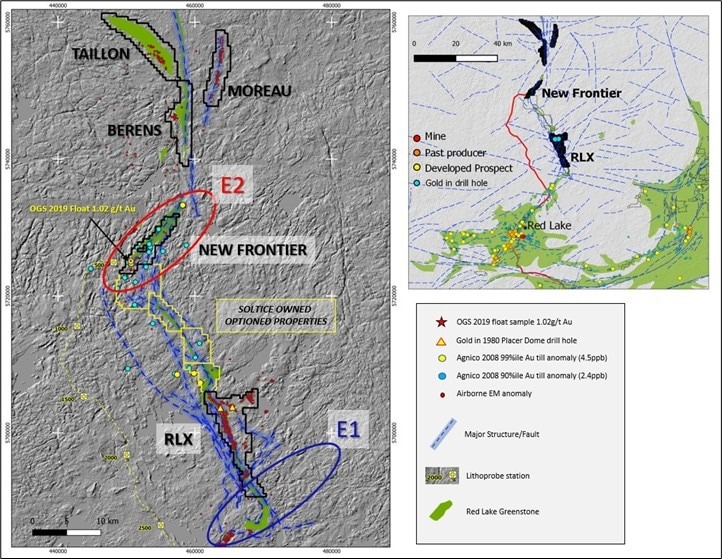 Solstice’s total land position in the northwestern extension of the Red Lake Gold Camp relative to two OGS interpreted translithospheric structures named E1 and E21, 2, 3. See January 10, 2022, news release for more details. Image Credit: Solstice Gold Corp.
The significant land holdings of over 180 km2 of potential greenstone extensions and significant regional structures have been focused on RLX. The initial 5,000 m (10–15 drill hole program) was intended to explore three primary target locations at a depth of about 250 m below the surface on average.
From a total of 5,000 m, the company has finished four drill holes, totaling 2,075 m, and is currently working on the fifth. Targets described in the company's news release from June 21st, 2022, are tested with holes.
As we approach the halfway mark of our first program at RLX, we’re excited to provide more information to support our thesis of a potential extension of the Red Lake Camp. Observations made around the kilometer scale and extent of alteration, as well as the presence of sulfides and iron formation confirm the various target settings we anticipated.
Mike Timmins, CEO, Solstice Gold Corp.
“These early indications reinforce our premise for assembling an attractive land position with large-scale regional features, proximal to interpreted deep-tapping structures and focusing our technical work on this under explored corner of the Camp. Sampled intervals of the first drill holes, including the wide alteration zones, have been submitted for analysis and we anticipate receiving results in the fourth quarter,” Timmins added.
Program Highlights:
- Drilling in the Central Target region was intended to identify structurally hosted alteration zones that are comprised of biotite-sericite schists. In all three of the drill holes used to test these targets, biotite-sericite, +/- KSpar flooded zones, and +/- quartz were found in severely changed alteration zones. According to 3D EM modeling, these are correlated with regions of moderate to poor conductivity. The ALTs are created within roughly 50 m intervals in each hole and have core lengths ranging from 9 to 36 m. Based on the present interpretation and the orientation of the drill core, the compnay estimates that the true thicknesses of ALT zones are approximately 90% of core lengths.
- Alteration assemblages have totally replaced the primary rock types within the ALTs. The ALT’s recognized mineralization includes uncommon chalcopyrite, semi-massive pyrite-pyrrhotite, and locally 1 m sections of semi-massive pyrite-pyrrhotite, as well as typically trace dispersed pyrite-pyrrhotite with local accumulations up to many percentages across decimeter sections.
- The ALTs exhibit a primary foliation that is overprinted by a robust secondary (S2) fabric that is composed of biotite and sericite. They are believed to be connected to a significant structural zone that has affected older rock units (mostly intermediate volcanics) and has undergone extensive alteration from fluids that are primarily K-rich. Pyroxenitic gabbro, granite, etc. are intrusive rocks that are found up-hole of the ALTs and, by definition, are likely to have taken advantage of significant translithospheric structures. These intrusive rocks also partially correlate with mapped sanukitoids at the surface. Metamorphic grade within the main target ALT’s is generally upper greenschist facies.
- Drilling in the Central Target region indicates that the changed zones can be associated with at least a 1.1 km strike length. These zones’ corresponding EM responses can be followed for more than 7 km northward. Drilling will continue in order to test these extensions.
- A significant correlation between the logged rock units and the airborne EM 3D inversion model demonstrates the effectiveness of EM as a geophysical technique, boosting the confidence in the present target selection.
- Hole RLXDH22-02, which intersected a 90 m thick iron deposit with local semi-massive sulfides and alteration, explored a secondary target.
Journal References:
- Lewis, S.O. 2021. Deep tapping seismic structure in the Red Lake district; in Ontario Geological Survey, Resident Geologist Program, Recommendations for Exploration 2020-2021, p.9-13.
- Zeng, Fafu and Calvert, Andrew. 2011. Imaging the upper part of the Red Lake greenstone belt, northwestern Ontario, with 3-D traveltime tomography. Canadian Journal of Earth Sciences, v.43. p.849-863. https://doi.o rg/10.1139/e06-027.
- Calvert, Andrew J. and Cruden, Alexander R. 2004. Seismic evidence for the preservation of the Archean Uchi granite-greenstone belt by crustal-scale extension. Tectonophysics 388 p.135-143
Source: https://solsticegold.com/