Jul 30 2013
Infrastructure Materials Corp. (the “Company”) is pleased to announce the completion of a Induced Polarization (IP)/Resistivity geophysical orientation survey program on its Clay Peters Project in Nevada(the “Project”), referred to in prior communications as “Kope Scheelite”.
Following positive results of the magnetic survey earlier in 2013(see news release dated April 22, 2013 available on www.sedar.com and www.infrastructurematerialscorp.com), the Company retained Zonge Geosciences Inc. to conduct an IP/Resistivity survey to further define the geophysical features and identify drilling targets.
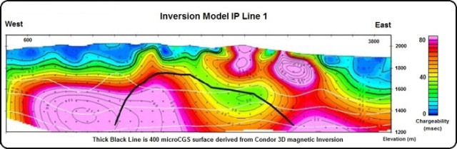
Three orientation/reconnaissance lines were surveyed: two lines crossed the southern magnetic peak and one line tested the shallower northern magnetic feature in the vicinity of the Clay Peters Mine. Processing of the survey data included 2D inversion of the IP/Resistivity data and these vertical sections were then referenced to the 3D magnetic model constructed from the previous survey. Results are consistent with a copper-gold porphyry target, associated alteration within the porphyry and surrounding rocks and multiphase intrusions possibly including later intrusions and faulting. While the three surveyed lines do not fully resolve the source of the magnetic features, they do provide necessary assistance for targeting the next stage of drilling. Following results from drilling to confirm geophysical interpretation, additional geophysics could be conducted to more completely resolve the extent of the targets.
"With each survey and exploration phase of the Clay Peters Project we are getting a clearer picture of the exploration targets and potential of this property" notes Mason Douglas, President and CEO of Infrastructure Materials Corp. "Later this summer we intend to drill test targets that have been refined by this survey."
To date, the Company has completed several phases of exploration on the Project. In addition to two recent phases of the geophysical work mentioned above, the Company has completed 2,309.8 meters (7,578 feet) of drilling in 19 reverse circulation holes during September and October of 2012 (see press release dated January 16, 2013). Drilling identified copper and gold mineralization hosted both in the intrusive and in adjacent sediments. In addition to those elements, a complex suite of anomalous elements including antimony, bismuth, cobalt, cadmium, gallium, germanium, molybdenum, indium, selenium, tellurium, tin and tungsten were found to form zones in and surrounding the mineralization. The Company plans to commence with a 2,134 meter (7,000 feet) drill program this summer to further delineate the extent of the high priority geophysical targets.
About the Clay Peters Project
The Project consists of 263 mineral claims located in Mineral County, Nevada, approximately 11 miles northeast of the town of Mina. The Project is located in the Walker Lane, a structural belt, which prolifically hosts many significant deposits, including Nevada Copper Corp.'s recently developed Pumpkin Hollow deposits (total Measured and Indicated copper resource of 3.1 billion kilograms (6.8 billion pounds) for the combined Western and Eastern Deposits (Western Open-Pit Deposits: 664 million tonnes, averaging 0.37% Cu with a 0.15% cutoff; and Eastern Underground Deposits: 45.9 million tonnes averaging 1.45% Cu with a 0.75% cutoff - source: Nevada Copper Corp. news release dated October 19, 2012). Infrastructure Materials Corp. believes the Pumpkin Hollow deposits are an analogue for the copper mineralization at the Company's Clay Peters Project. Initial exploration appears to indicate that the Clay Peters Project may have some higher grade gold mineralization that, in places, differentiates it from the mineralization style at Pumpkin Hollow. Pumpkin Hollow and the nearby Yerington mine are located approximately 97 km (60 miles) northwest of the Clay Peters Project. The historical Yerington mine, operated by Anaconda from 1953 to 1978, produced more than 147 million tonnes (162 million tons) of ore grading 0.6% copper.
John Harrop, P.Geo., FGS of Coast Mountain Geological Ltd., a qualified person as defined by Canadian National Instrument 43-101 Standards of Disclosure for Mineral Projects, reviewed and approved the technical disclosures of this press release on behalf of the Company.
Infrastructure Materials Corp. is a Reno, Nevada based exploration stage company that is directing its efforts to the exploration and development, if warranted, of precious metal properties located in Nevada and cement grade limestone deposits in strategic locations in the United States.
For further information please see our public filings at www.sedar.com and www.sec.gov/edgar.shtml or contact:
Source: http://www.infrastructurematerialscorp.com/