Class 1 Nickel and Technologies Limited (CSE: NICO | OTCQB: NICLF) (“Class 1” or the “Company”) has officially kicked off its 2025 summer exploration program at its 100 %-owned River Valley PGE-Cu-Ni Project (“RV Project” or “the Property”), located approximately 65 kilometres northeast of Sudbury, Ontario.
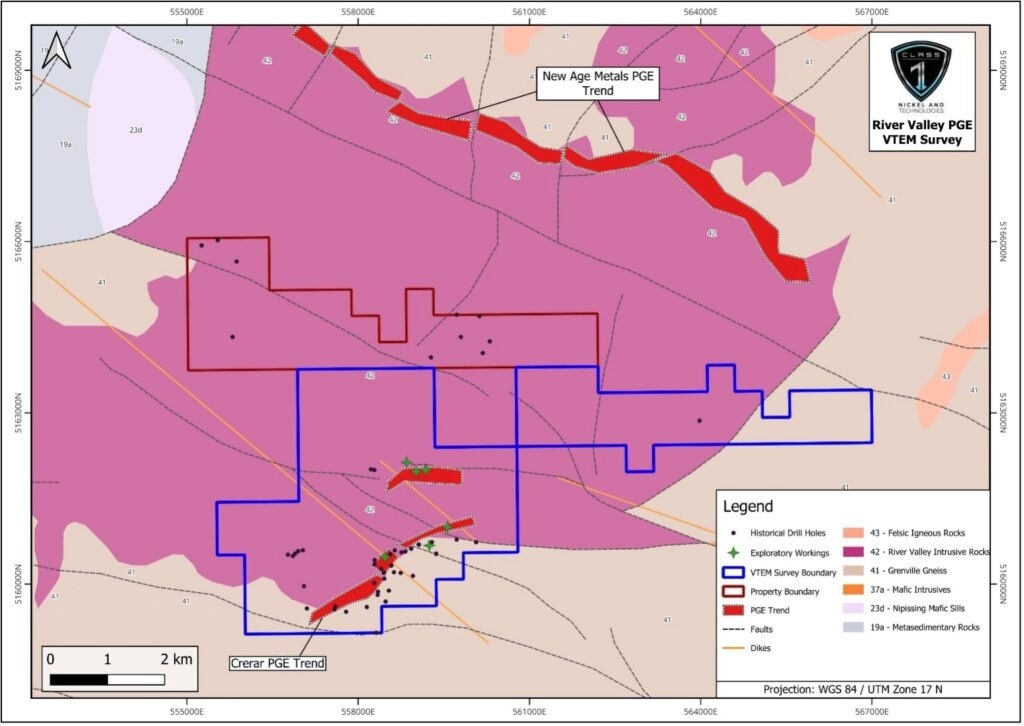 Outline of the RV Project mining claims (red boundary) that define the River Valley PGE Project and the area surveyed (blue boundary) using Geotech’s VTEMTM Plus airborne system (base geology from OGS, 2011: Ontario Geological Survey. 1:250 000 scale Bedrock Geology of Ontario; Miscellaneous Release–Data 126 – Rev.1). Image Credit: Class 1 Nickel and Technologies Limited
Covering roughly 2916 hectares, the Property hosts several kilometres of prospective geology and known PGE-bearing sulphide mineralization classified as Contact-Style PGE-Cu-Ni, hosted within the River Valley Intrusion (RVI). The project lies just south of New Age Metals Inc.’s advanced-stage River Valley Palladium Project.
This season’s field program is centered on geological mapping and sampling, as well as ground-truthing targets identified through a recently completed 254 line-kilometre helicopter-borne VTEM™ Plus time-domain electromagnetic and horizontal magnetic gradiometric survey (see Class 1 news release dated May 27, 2025).
The team will also conduct detailed assessments of existing sulphide occurrences on the Property. Exploration results will be reported as they become available.
We are excited to have our 2025 exploration program at the River Valley PGE Property underway, which includes field-checking the geophysical targets from the first-ever VTEM™ Plus survey covering most of the property, including the multi-kilometer Crerar PGE Trend. As new targets emerge, our technical team will conduct detailed surface mapping and sampling, and if justified, perform targeted geophysical surveys and trenching to expose and understand any new PGE-Cu-Ni zones.
David Fitch, Chief Executive Officer, Class 1 Nickel and Technologies Limited
The Company reminds readers that geophysical surveys are interpretive tools. While they can identify conductive targets, these signals may result from non-mineral sources such as graphite, structural features, or barren sulphides. Additionally, exploration results from neighboring properties do not necessarily reflect the mineral potential of the RV Project itself.
River Valley PGE-Cu-Ni Project
The RV Project focuses on known Contact-Style PGE-Cu-Ni sulphide mineralization along the Crerar PGE Trend, located in the southern part of the River Valley Intrusion.
The project provides Class 1 with additional PGE exploration potential and exposure to critical minerals including copper and nickel. Geologically, the area is underlain by gabbroic to anorthositic rocks of Paleoproterozoic age, with the exploration program targeting the productive Marginal and Inclusion-Bearing zones.
Versatile Time Domain Electromagnetic (VTEM™) Plus Survey
Conducted in March 2025 by Geotech Ltd., the helicopter-borne survey spanned 254 line-kilometres across the River Valley PGE-Cu-Ni Project. The primary geophysical tools included a VTEM™ Plus system and a horizontal magnetic gradiometer with dual caesium sensors.
Supporting equipment featured GPS navigation and a radar altimeter. Flight lines were spaced 100 metres apart in a northwest-southeast orientation, with tie lines every 1 kilometre running northeast. All data were collected using the WGS 84 Datum, UTM Zone 17 North.
VTEMTM and Magnetic Survey Interpretation
Initial VTEM™ conductor anomalies were identified based on conductance levels, then reviewed for cultural interference using satellite imagery. Validated targets were prioritized and cross-referenced with additional datasets, including total magnetic intensity (TMI), vertical magnetic derivatives (1VD and TDR), local geology, historical drilling, and known sulphide occurrences.
Electromagnetic picks, known mineralized trends, and potential new zones of sulphide mineralization are among the promising results from the recent survey. These findings will guide the focus of this summer’s exploration program, which includes geophysical ground-truthing, detailed mapping and sampling, additional surveys, and trenching.