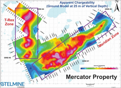
Contour map of the apparent chargeability of the Meridian and TRex zones on the Mercator property. Note the 3.7 km anomaly showing values > 13.5 mV/V between lines L700E et L-4400E on Grid 1 (Meridian Zone) and a similar anomaly on Grid 3 (T-Rex Zone) remaining open toward the NE and west. Image Credit: Stelmine
The IP survey had two main goals: 1) improve the precision of the geophysical data by lowering line spacing on the Meridian Zone to maximize the choice of drilling sites, and 2) discover additional expansions to the known Zone (Meridian) inside the T-Rex sector.
The TRex Zone was called after the results of a till survey done in 2022 that identified an Au, As, and Cu anomalous region north of the Meridian Zone. A brief investigation of the T-Rex Zone revealed many sulfide-rich iron formations and metasediments outcrops and boulders. The IP survey results are intriguing, emphasizing a new 2 km × 300 m anomaly.
Pole-Dipole IP/Resistivity Survey
The IP survey setup allows for a depth of study of up to 175 m, which is substantially deeper than the previous survey (80 m). The new survey discovered many IP anomalies that were often linked with a significant drop in resistivity, magnetic structures, and/or sulfide or ferromagnesian mineral-rich lithological units.
The revised apparent chargeability and resistivity contour maps show more outlined sectors in the Meridian zone’s core, which is mainly oriented NE/SW and stretches for 3.7 km. In numerous situations, the inversion model reveals the presence of sub-horizontal conductors.
The new NNE/SSW-oriented chargeability/resistivity anomalies across 2 km on the T-Rex grid are among the strongest discovered to date on the Mercator project (in part exceeding 25mV/V).