Kutcho Copper Corp. (“Kutcho Copper” or the “Company”) has begun the scheduled geophysical surveys at its viability stage, a high-grade copper-zinc development project situated in north-western British Columbia.
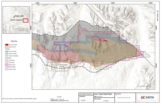 Location of VTEM, ZTEM, and Seismic surveys. Image Credit: Kutcho Copper Corp.
We announced our plans for a regional exploration program in February, that program has now commenced, beginning with a dual VTEM and ZTEM aerial geophysical survey. VTEM is useful for definition of shallow VMS mineralization and can clearly pick out potential targets to 300m depth such as the Main and Sumac deposits.
The ZTEM survey is focused deeper in the 300-800 m depth range and will cover around 90% of the prospective Kutcho Formation on the property. This latter technique has been chosen to highlight potential targets similar to our Esso deposit. Combined, the two surveys will investigate a significantly larger volume of prospective Kutcho Formation rocks, particularly to depth, than ever before.
In addition, within our prime mineralized corridor of Main-Sumac and Esso, we will be utilizing a seismic survey to define the orientation and depth of the most prospective rock package and extending coverage up to 2 km west of the high-grade Esso deposit. The combination of our new and old data will be used to develop a follow-up drill program for the most compelling targets.
Vince Sorace, President & CEO, Kutcho Copper Corp.
For the first time, these programs illustrate that the highly effective new ZTEM and VTEM geophysical techniques will have been applied together to assess the majority of prospective mineralized horizons that already host the three recognized VMS deposits.
Highlights of the Program Underway Include
- 802-line km of VTEM (Versatile Time domain Electro-Magnetic) on 100 m line spacing—depth focus 0-300 m (comprises total magnetic intensity data to improve the projects’ magnetic data coverage).
- Integrated targeting will be conducted on data as it is expelled from providers from the different surveys for the development of drill programs on demanding targets.
- ZTEM and VTEM surveys are owing to complete data acquisition in mid-July.
- 1,557-line km of ZTEM (Z-Axis Tipper Electro-Magnetic) on 200 m line spacing—depth focus 300-800 m, but has been shown to have a maximum 1,500 m of depth penetration in some positions.
- The seismic survey with a depth focus of 0-1,000 m.
The Kutcho Project covers approximately 90% of the potential Kutcho Formation rocks east of Dease Lake, B.C. These potential volcanic rocks are folded, repeating the favorable mineralized horizon that hosts the Main, Sumac, and Esso volcanogenic massive sulfide (“VMS”) deposits three times inside the Project boundary, which includes the areas hosting the known deposits.